


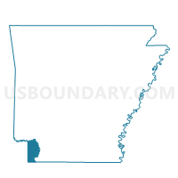
Boyd Precinct, Miller County, Arkansas
About
Outline

Summary
| Unique Area Identifier | 527291 |
| Name | Boyd Precinct |
| County | Miller County |
| State | Arkansas |
| Area (square miles) | 21.18 |
| Land Area (square miles) | 21.17 |
| Water Area (square miles) | 0.02 |
| % of Land Area | 99.93 |
| % of Water Area | 0.07 |
| Latitude of the Internal Point | 33.35274910 |
| Longtitude of the Internal Point | -93.91556100 |
Maps


Graphs
Select a template below for downloading or customizing gragh for Boyd Precinct, Miller County, Arkansas


Neighbors
Neighoring Voting District (by Name) Neighboring Voting District on the Map
- Central Precinct, Miller County, AR
- Fouke Precinct, Miller County, AR
- Greenwich Village Precinct, Miller County, AR
- Pleasant Hill Precinct, Miller County, AR
- Shiloh Precinct, Miller County, AR
- Union Precinct, Miller County, AR
Top 10 Neighboring County Subdivision (by Population) Neighboring County Subdivision on the Map
- Garland township, Miller County, AR (33,493)
- Beech township, Miller County, AR (3,773)
- Cleveland township, Miller County, AR (3,139)
- Days Creek township, Miller County, AR (1,032)